
Burgundy topographic map
Interactive map
Click on the map to display elevation.
About this map
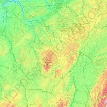
Name: Burgundy topographic map, elevation, terrain.
Location: Burgundy, Metropolitan France, France (46.15601 2.84448 48.40006 5.51887)
Average elevation: 286 m
Minimum elevation: 47 m
Maximum elevation: 1,513 m
Other topographic maps
Click on a map to view its topography, its elevation and its terrain.
7
France > Ile-de-France > Yvelines > Poissy
7, La Bidonnière, Poissy, Saint-Germain-en-Laye, Yvelines, Ile-de-France, Metropolitan France, 78300, France
Average elevation: 109 m
Mérignat
France > Auvergne-Rhône-Alpes > Ain
Mérignat, Nantua, Ain, Auvergne-Rhône-Alpes, Metropolitan France, 01450, France
Average elevation: 417 m
Manjotier
France > Auvergne-Rhône-Alpes > Isère > Miribel-les-Échelles
Manjotier, Miribel-les-Échelles, Grenoble, Isère, Auvergne-Rhône-Alpes, Metropolitan France, 38380, France
Average elevation: 618 m
Rencurel
France > Auvergne-Rhône-Alpes > Isère
Rencurel, Grenoble, Isère, Auvergne-Rhône-Alpes, Metropolitan France, 38680, France
Average elevation: 1,099 m
Le Grand-Lemps
France > Auvergne-Rhône-Alpes > Isère
Le Grand-Lemps, La Tour-du-Pin, Isère, Auvergne-Rhône-Alpes, Metropolitan France, 38690, France
Average elevation: 512 m
city de boutet de monvel (ethanlecartographe
France > Grand Est > Meurthe-et-Moselle > Lunéville
city de boutet de monvel (ethanlecartographe, Lunéville, Meurthe-et-Moselle, Grand Est, Metropolitan France, 54300, France
Average elevation: 240 m
Isère
Isère, Auvergne-Rhône-Alpes, Metropolitan France, France
Average elevation: 868 m
Rambe
France > Auvergne-Rhône-Alpes > Puy-de-Dôme > Peschadoires
Rambe, Peschadoires, Thiers, Puy-de-Dôme, Auvergne-Rhône-Alpes, Metropolitan France, 63920, France
Average elevation: 361 m
Quéant
France > Hauts-de-France > Pas-de-Calais
Quéant, Arras, Pas-de-Calais, Hauts-de-France, Metropolitan France, 62860, France
Average elevation: 85 m
Le Born
France > Occitania > Haute-Garonne
Le Born, Toulouse, Haute-Garonne, Occitania, Metropolitan France, 31340, France
Average elevation: 169 m
Fontaine
France > Auvergne-Rhône-Alpes > Isère
Fontaine, Grenoble, Isère, Auvergne-Rhône-Alpes, Metropolitan France, 38600, France
Average elevation: 253 m
Noreuil
France > Hauts-de-France > Pas-de-Calais
Noreuil, Arras, Pas-de-Calais, Hauts-de-France, Metropolitan France, 62128, France
Average elevation: 97 m
Montagnole
France > Auvergne-Rhône-Alpes > Savoy
Montagnole, Chambéry, Savoy, Auvergne-Rhône-Alpes, Metropolitan France, 73000, France
Average elevation: 685 m
Mézos
France > Nouvelle-Aquitaine > Landes
Mézos, Mont-de-Marsan, Landes, Nouvelle-Aquitaine, Metropolitan France, 40170, France
Average elevation: 40 m
Village Tumukuru
France > French Polynesia > Tatakoto
Village Tumukuru, Tatakoto, Tuamotu-Gambier, French Polynesia, 98783, France
Average elevation: 1 m
Champniers
France > Nouvelle-Aquitaine > Charente
Champniers, Angoulême, Charente, Nouvelle-Aquitaine, Metropolitan France, 16430, France
Average elevation: 92 m
Montferrand
Montferrand, Carcassonne, Aude, Occitania, Metropolitan France, 11320, France
Average elevation: 222 m
Ain
Ain, Auvergne-Rhône-Alpes, Metropolitan France, France
Average elevation: 418 m
Rangiroa
France > French Polynesia > Rangiroa
Rangiroa, Tuamotu-Gambier, French Polynesia, 98775, France
Average elevation: 0 m
Maine-et-Loire
Maine-et-Loire, Pays de la Loire, Metropolitan France, France
Average elevation: 76 m
Custines
France > Grand Est > Meurthe-et-Moselle
Custines, Nancy, Meurthe-et-Moselle, Grand Est, Metropolitan France, 54670, France
Average elevation: 275 m
Sus
France > Nouvelle-Aquitaine > Pyrénées-Atlantiques
Sus, Oloron-Sainte-Marie, Pyrénées-Atlantiques, Nouvelle-Aquitaine, Metropolitan France, 64190, France
Average elevation: 162 m
Domaine de Saint-Lambert
France > Occitania > Lozère > Marvejols
Domaine de Saint-Lambert, Promenade Louis Cabanettes, Marvejols, Mende, Lozère, Occitania, Metropolitan France, 48100, France
Average elevation: 725 m
Pregnin
France > Auvergne-Rhône-Alpes > Ain > Saint-Genis-Pouilly
Pregnin, Saint-Genis-Pouilly, Gex, Ain, Auvergne-Rhône-Alpes, Metropolitan France, 01630, France
Average elevation: 473 m
Juan de Nova Island
France > French Southern and Antarctic Lands
Juan de Nova Island, Scattered Islands in the Indian Ocean, French Southern and Antarctic Lands, France
Average elevation: 0 m
Saint-Pierre-de-Cernières
Saint-Pierre-de-Cernières, Bernay, Eure, Normandy, Metropolitan France, 27390, France
Average elevation: 201 m
Le Not
France > Auvergne-Rhône-Alpes > Isère > Saint-Hilaire-de-la-Côte
Le Not, Saint-Hilaire-de-la-Côte, Vienne, Isère, Auvergne-Rhône-Alpes, Metropolitan France, 38260, France
Average elevation: 406 m
Entrange Cité
Entrange Cité, Entrange, Thionville, Moselle, Grand Est, Metropolitan France, 57330, France
Average elevation: 237 m
Saint-Nazaire
France > Pays de la Loire > Loire-Atlantique
Saint-Nazaire, Loire-Atlantique, Pays de la Loire, Metropolitan France, 44600, France
Average elevation: 6 m
Cachar
France > Occitania > Gard > Saint-Jean-du-Gard
Cachar, Saint-Jean-du-Gard, Alès, Gard, Occitania, Metropolitan France, 30270, France
Average elevation: 312 m
Mandrel
France > Grand Est > Aube > Lignol-le-Château
Mandrel, Lignol-le-Château, Bar-sur-Aube, Aube, Grand Est, Metropolitan France, 10200, France
Average elevation: 262 m
Sénestis
France > Nouvelle-Aquitaine > Lot-et-Garonne
Sénestis, Marmande, Lot-et-Garonne, Nouvelle-Aquitaine, Metropolitan France, 47430, France
Average elevation: 32 m