
Moscow Oblast topographic map
Interactive map
Click on the map to display elevation.
About this map
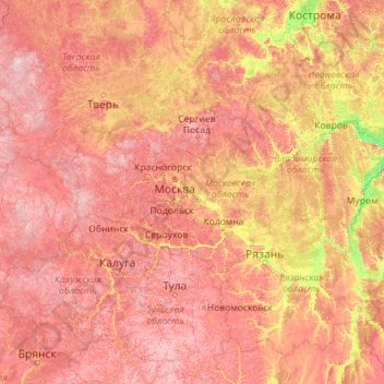
Name: Moscow Oblast topographic map, elevation, terrain.
Location: Moscow Oblast, Central Federal District, Russia (52.94432 35.47539 58.06432 40.59539)
Average elevation: 167 m
Minimum elevation: 71 m
Maximum elevation: 341 m
Most of the eastern part of Moscow Oblast is taken by the vast Meshchera Lowlands with much wetland in their eastern part. Their highest hill peaks at 214 meters (702 ft) but the average heights are 120–150 meters (390–490 ft). Most lakes of the lowlands, such as Lakes Chyornoye and Svyatoye, are of glacial origin. Here lies the lowest natural elevation of the region, the water level of Oka River at 97 meters (318 ft).
Other topographic maps
Click on a map to view its topography, its elevation and its terrain.
Zhukovsky
Russia > Moscow Oblast > Zhukovsky > Zhukovsky
Zhukovsky, Moscow Oblast, Central Federal District, Russia
Average elevation: 125 m
Dmitrovsky District
Dmitrovsky District, Moscow Oblast, Central Federal District, Russia
Average elevation: 175 m
Dmitrov
Russia > Moscow Oblast > Dmitrov
Dmitrov, Dmitrovsky District, Moscow Oblast, Central Federal District, 141800, Russia
Average elevation: 155 m