
Thank you for supporting this site ❤️
Make a donation
Make a donation
Brazito topographic map
Click on the map to display elevation.
Thank you for supporting this site ❤️
Make a donation
Make a donation
About this map
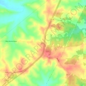
Name: Brazito topographic map, elevation, terrain.
Location: Brazito, Cole County, Missouri, United States (38.42561 -92.32349 38.46561 -92.28349)
Average elevation: 233 m
Minimum elevation: 194 m
Maximum elevation: 267 m
Thank you for supporting this site ❤️
Make a donation
Make a donation
Other topographic maps
Click on a map to view its topography, its elevation and its terrain.