
Thank you for supporting this site ❤️
Make a donation
Make a donation
Léotoing topographic map
Click on the map to display elevation.
Thank you for supporting this site ❤️
Make a donation
Make a donation
About this map
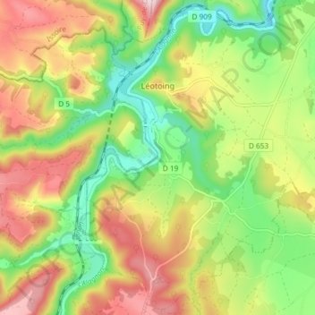
Name: Léotoing topographic map, elevation, terrain.
Average elevation: 566 m
Minimum elevation: 439 m
Maximum elevation: 719 m
Thank you for supporting this site ❤️
Make a donation
Make a donation
Other topographic maps
Click on a map to view its topography, its elevation and its terrain.
Le Croizet
France > Auvergne-Rhône-Alpes > Haute-Loire > Saint-Privat-du-Dragon
Average elevation: 644 m
La Biela
France > Auvergne-Rhône-Alpes > Haute-Loire > Saint-Ferréol-d'Auroure
Average elevation: 655 m
Thank you for supporting this site ❤️
Make a donation
Make a donation