
Thank you for supporting this site ❤️
Make a donation
Make a donation
Mariehamn topographic map
Click on the map to display elevation.
Thank you for supporting this site ❤️
Make a donation
Make a donation
About this map
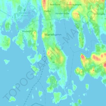
Name: Mariehamn topographic map, elevation, terrain.
Location: Mariehamn, Mariehamn sub-region, Åland Islands, Finland (60.04667 19.91311 60.12899 19.97328)
Average elevation: 6 m
Minimum elevation: -3 m
Maximum elevation: 55 m
Thank you for supporting this site ❤️
Make a donation
Make a donation
Other topographic maps
Click on a map to view its topography, its elevation and its terrain.