
Thank you for supporting this site ❤️
Make a donation
Make a donation
Valencia topographic map
Click on the map to display elevation.
Thank you for supporting this site ❤️
Make a donation
Make a donation
About this map
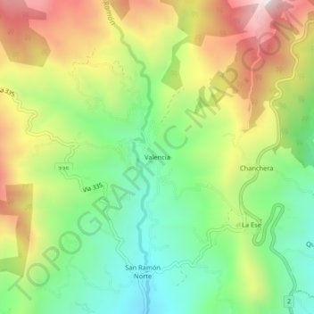
Name: Valencia topographic map, elevation, terrain.
Location: Valencia, Páramo, Pérez Zeledón, San José, 11911, Costa Rica (9.43060 -83.74725 9.47060 -83.70725)
Average elevation: 1,379 m
Minimum elevation: 1,012 m
Maximum elevation: 1,884 m
Thank you for supporting this site ❤️
Make a donation
Make a donation
Other topographic maps
Click on a map to view its topography, its elevation and its terrain.