
Bronnegerveen topographic map
Interactive map
Click on the map to display elevation.
About this map
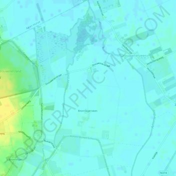
Name: Bronnegerveen topographic map, elevation, terrain.
Location: Bronnegerveen, Borger-Odoorn, Drenthe, Nederland (52.94360 6.81276 52.97806 6.86068)
Average elevation: 8 m
Minimum elevation: 4 m
Maximum elevation: 25 m
Other topographic maps
Click on a map to view its topography, its elevation and its terrain.
Eeserveen
Nederland > Drenthe > Borger-Odoorn
Eeserveen, Borger-Odoorn, Drenthe, Nederland
Average elevation: 18 m
Exloërveen
Nederland > Drenthe > Borger-Odoorn
Exloërveen, Borger-Odoorn, Drenthe, Nederland
Average elevation: 11 m