
Kolguyev Island topographic map
Interactive map
Click on the map to display elevation.
Kolguyev Island
The island was explored in 1894 by the British naturalist Aubyn B. R. Trevor-Battye. He landed in June with an assistant, intending to spend about one month studying the wildlife, especially the birds. Due to mechanical problems with the vessel and a misunderstanding, they were left stranded on the island for 12 weeks. He published his study of the natural history and topography of Kolguyev as Ice-Bound on Kolguev (Trevor-Battye 1895). The book includes observations on the Nenets (whom he called Samoyed) who brought their reindeer to the island for summer grazing and to trap geese for trade in Russia. Trevor-Battye eventually left the island with these reindeer herders in September 1894, and had to travel 1,000 miles (1,600 km) overland from the Pechora River to Archangel. He described this journey in A Northern Highway of the Tsar (Trevor-Battye 1898).
About this map
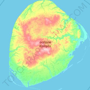
Name: Kolguyev Island topographic map, elevation, terrain.
Average elevation: 26 m
Minimum elevation: -5 m
Maximum elevation: 176 m
Other topographic maps
Click on a map to view its topography, its elevation and its terrain.