
Spring Lake topographic map
Interactive map
Click on the map to display elevation.
About this map
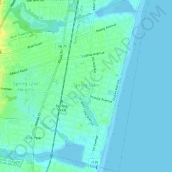
Name: Spring Lake topographic map, elevation, terrain.
Location: Spring Lake, Monmouth County, New Jersey, United States (40.13751 -74.03768 40.16909 -74.01508)
Average elevation: 5 m
Minimum elevation: -2 m
Maximum elevation: 21 m
Other topographic maps
Click on a map to view its topography, its elevation and its terrain.
Sandy Hook Lighthouse
United States > New Jersey > Monmouth County > Middletown Township > Fort Hancock
Average elevation: 1 m
Ellisdale
United States > New Jersey > Monmouth County > Upper Freehold Township
Average elevation: 34 m
Hilton
United States > New Jersey > Monmouth County > Atlantic Highlands
Atlantic Highlands has a humid subtropical climate (Cfa) and average monthly temperatures range from 32.6 °F (0.3 °C) in January to 75.9 °F (24.4 °C) in July. The hardiness zone is 7a or 7b depending upon elevation.
Average elevation: 17 m