
Make a donation
Brixentaler Ache topographic map
Click on the map to display elevation.
Make a donation
About this map
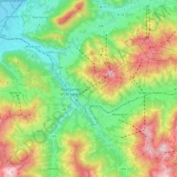
Name: Brixentaler Ache topographic map, elevation, terrain.
Average elevation: 1,014 m
Minimum elevation: 489 m
Maximum elevation: 1,943 m
Make a donation
Other topographic maps
Click on a map to view its topography, its elevation and its terrain.
Außersalvenberg
Österreich > Tirol > Bezirk Kitzbühel > Westendorf > Feichten
Average elevation: 944 m
Make a donation
Schwaigerberg
Österreich > Tirol > Bezirk Kitzbühel > Westendorf > Unterwindau
Average elevation: 924 m
Make a donation
Brixental
Österreich > Tirol > Bezirk Kitzbühel > Westendorf
Mit rund 24.000 Gästebetten, 1,68 Millionen Nächtigungen im Winter und 1,32 Millionen im Sommer (Stand 2018) stellt der Tourismus einen wichtigen Wirtschaftszweig dar. Die SkiWelt Wilder Kaiser – Brixental ist eines der größten Schigebiete Österreichs. Neben den zahlreichen Beherbergungsbetrieben und…
Average elevation: 998 m