
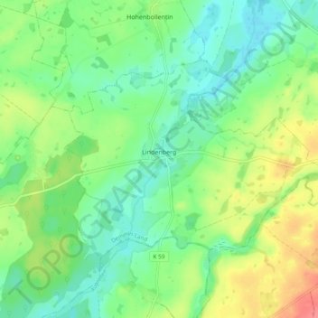
Lindenberg topographic map
Interactive map
Click on the map to display elevation.
About this map
Name: Lindenberg topographic map, elevation, terrain.
Average elevation: 53 m
Minimum elevation: 31 m
Maximum elevation: 91 m
Other topographic maps
Click on a map to view its topography, its elevation and its terrain.
Burg Stargard
Deutschland > Mecklenburg-Vorpommern > Mecklenburgische Seenplatte
Burg Stargard, Stargarder Land, Mecklenburgische Seenplatte, Mecklenburg-Vorpommern, 17094, Deutschland
Average elevation: 80 m
Neubrandenburg
Deutschland > Mecklenburg-Vorpommern > Mecklenburgische Seenplatte > Neubrandenburg > Neubrandenburg
Neubrandenburg, Mecklenburgische Seenplatte, Mecklenburg-Vorpommern, 17033, Deutschland
Average elevation: 38 m
Neubrandenburg
Deutschland > Mecklenburg-Vorpommern > Mecklenburgische Seenplatte
Neubrandenburg, Mecklenburgische Seenplatte, Mecklenburg-Vorpommern, Deutschland
Average elevation: 58 m