
Thank you for supporting this site ❤️
Make a donation
Make a donation
Alcobendas topographic map
Click on the map to display elevation.
Thank you for supporting this site ❤️
Make a donation
Make a donation
About this map
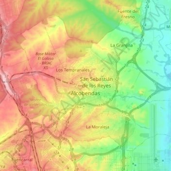
Name: Alcobendas topographic map, elevation, terrain.
Location: Alcobendas, Community of Madrid, Spain (40.50118 -3.70092 40.58881 -3.54950)
Average elevation: 666 m
Minimum elevation: 580 m
Maximum elevation: 771 m
Thank you for supporting this site ❤️
Make a donation
Make a donation
Other topographic maps
Click on a map to view its topography, its elevation and its terrain.