
Thank you for supporting this site ❤️
Make a donation
Make a donation
Berodia topographic map
Click on the map to display elevation.
Thank you for supporting this site ❤️
Make a donation
Make a donation
About this map
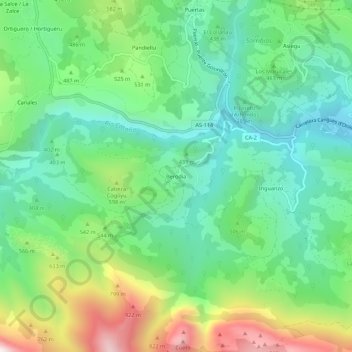
Name: Berodia topographic map, elevation, terrain.
Location: Berodia, Cabrales, Asturias, 33555, España (43.29051 -4.90132 43.33051 -4.86132)
Average elevation: 466 m
Minimum elevation: 180 m
Maximum elevation: 1,078 m
Thank you for supporting this site ❤️
Make a donation
Make a donation
Other topographic maps
Click on a map to view its topography, its elevation and its terrain.
Thank you for supporting this site ❤️
Make a donation
Make a donation