Coron topographic map
Interactive map
Click on the map to display elevation.
About this map
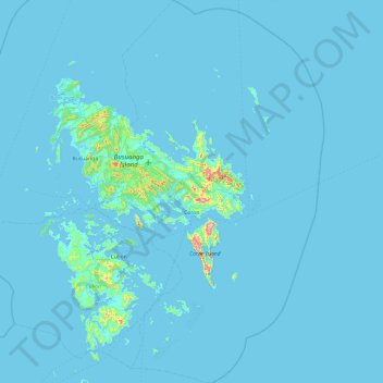
Name: Coron topographic map, elevation, terrain.
Location: Coron, Palawan, Mimaropa, 5316, Philippines (11.57919 119.95953 12.51964 120.53785)
Average elevation: 12 m
Minimum elevation: 0 m
Maximum elevation: 590 m
Other topographic maps
Click on a map to view its topography, its elevation and its terrain.
Poblacion 4
Philippines > Palawan > Coron
Poblacion 4, Coron, Palawan, Mimaropa, 5316, Philippines
Average elevation: 31 m
Dit
Philippines > Palawan > Agutaya
Dit, Agutaya, Palawan, Mimaropa, 5320, Philippines
Average elevation: 34 m
Apo Island
Philippines > Palawan > Coron
Apo Island, Coron, Palawan, Mimaropa, 5316, Philippines
Average elevation: 27 m
Busuanga Island
Busuanga Island, Coron, Palawan, Mimaropa, 5316, Philippines
Average elevation: 33 m