
Sogod topographic map
Interactive map
Click on the map to display elevation.
About this map
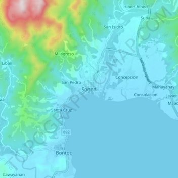
Name: Sogod topographic map, elevation, terrain.
Location: Sogod, Southern Leyte, Eastern Visayas, 6606, Philippines (10.34459 124.94080 10.42459 125.02080)
Average elevation: 94 m
Minimum elevation: 0 m
Maximum elevation: 787 m
Other topographic maps
Click on a map to view its topography, its elevation and its terrain.
Panaon Island
Panaon Island, Southern Leyte, Eastern Visayas, Philippines
Average elevation: 61 m
Libagon
Libagon, Southern Leyte, Eastern Visayas, 6615, Philippines
Average elevation: 140 m
Maasin
Philippines > Southern Leyte > Maasin
Maasin, Southern Leyte, Eastern Visayas, Philippines
Average elevation: 90 m
San Juan
San Juan, Southern Leyte, Eastern Visayas, 6611, Philippines
Average elevation: 95 m