
Niederstocken topographic map
Interactive map
Click on the map to display elevation.
About this map
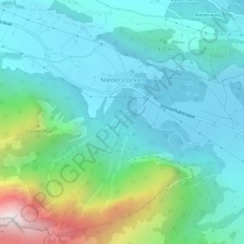
Name: Niederstocken topographic map, elevation, terrain.
Average elevation: 900 m
Minimum elevation: 611 m
Maximum elevation: 1,969 m
Other topographic maps
Click on a map to view its topography, its elevation and its terrain.
Stockhorn
Schweiz > Bern > Verwaltungskreis Thun > Stocken-Höfen
Stockhorn, Stocken-Höfen, Verwaltungskreis Thun, Verwaltungsregion Oberland, Bern, 3632, Schweiz
Average elevation: 1,684 m