
Thank you for supporting this site ❤️
Make a donation
Make a donation
Pellheim topographic map
Click on the map to display elevation.
Thank you for supporting this site ❤️
Make a donation
Make a donation
About this map
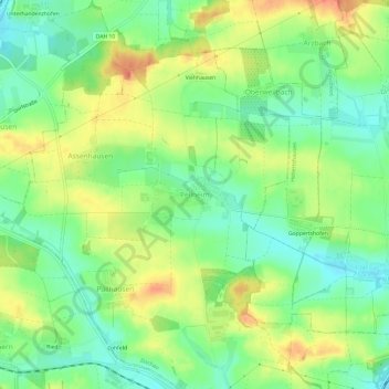
Name: Pellheim topographic map, elevation, terrain.
Location: Pellheim, Dachau, Landkreis Dachau, Bavaria, 85244, Germany (48.27487 11.39691 48.31487 11.43691)
Average elevation: 503 m
Minimum elevation: 478 m
Maximum elevation: 535 m
Thank you for supporting this site ❤️
Make a donation
Make a donation