
Vila Meã topographic map
Interactive map
Click on the map to display elevation.
About this map
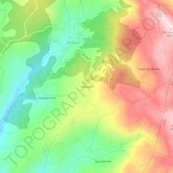
Name: Vila Meã topographic map, elevation, terrain.
Location: Vila Meã, Moledo, Castro Daire, Viseu, Portugal (40.79869 -7.88689 40.83869 -7.84689)
Average elevation: 646 m
Minimum elevation: 413 m
Maximum elevation: 921 m
Other topographic maps
Click on a map to view its topography, its elevation and its terrain.
Lamas
Portugal > Viseu > Castro Daire > Moledo
Lamas, Moledo, Castro Daire, Viseu, 3600-432, Portugal
Average elevation: 534 m