
Make a donation
Rysy topographic map
Click on the map to display elevation.
Make a donation
Rysy
It is possible to reach the peak from the Slovak side, starting at Štrbské pleso and passing Chata pod Rysmi, a mountain chalet at an altitude of 2,250 m (7,380 ft). Between November 1 and June 15, the trail and chalet on the Slovak side are closed.
Make a donation
About this map
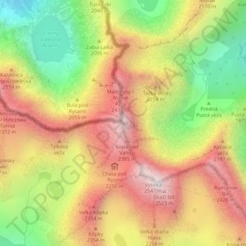
Name: Rysy topographic map, elevation, terrain.
Location: Rysy, District of Poprad, Region of Prešov, Slovakia (49.17927 20.08841 49.17937 20.08851)
Average elevation: 2,005 m
Minimum elevation: 1,423 m
Maximum elevation: 2,528 m
Make a donation
Other topographic maps
Click on a map to view its topography, its elevation and its terrain.
Tatranská Javorina
Slovakia > Region of Prešov > District of Poprad
The municipality lies at an altitude of 1000 metres. It is located in the Javorová Valley in the Tatra Mountains at the Polish-Slovak border.
Average elevation: 1,381 m
Ždiar
Slovakia > Region of Prešov > District of Poprad
The municipality lies at an elevation of 896 meters at the base of the High Tatras and covers an area of 27.323 km2. It has a population of about 1,340 people.
Average elevation: 1,105 m
Spišský Štiavnik
Slovakia > Region of Prešov > District of Poprad
The municipality lies at an altitude of 567 metres and covers an area of 18.364 km2. It has a population of about 2150 people.
Average elevation: 635 m
Make a donation
Štrba - Štrbské pleso
Slovakia > Region of Prešov > District of Poprad > Štrba
Average elevation: 1,597 m
Starý Smokovec
Slovakia > Region of Prešov > District of Poprad > Vysoké Tatry
Average elevation: 1,065 m
Batizovce
Slovakia > Region of Prešov > District of Poprad
The municipality lies at an altitude of 756 metres and covers an area of 14.348 km². It has a population of about 2125 people.
Average elevation: 785 m
Make a donation
Poprad
Slovakia > Region of Prešov > District of Poprad
Poprad lies at an altitude of 672 metres (2,205 ft) above sea level and covers an area of 63 square kilometres (24.3 sq mi). It is located in northeastern Slovakia, about 110 kilometres (68 mi) from Košice and 330 kilometres (205 mi) from Bratislava (by road).
Average elevation: 709 m
Ždiar
Slovakia > Region of Prešov > District of Poprad
The municipality lies at an elevation of 896 meters at the base of the High Tatras and covers an area of 27.323 km2. It has a population of about 1,340 people.
Average elevation: 1,208 m
Nová Lesná
Slovakia > Region of Prešov > District of Poprad
The municipality lies at an altitude of 747 metres and covers an area of 4.159 km². It has a population of about 1520 people.
Average elevation: 790 m
Make a donation