
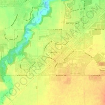
Chappelle topographic map
Interactive map
Click on the map to display elevation.
About this map
Name: Chappelle topographic map, elevation, terrain.
Average elevation: 695 m
Minimum elevation: 670 m
Maximum elevation: 709 m
Other topographic maps
Click on a map to view its topography, its elevation and its terrain.
Sherwood Park
Canada > Alberta > Division No. 11
Sherwood Park, Division No. 11, Alberta, Canada
Average elevation: 691 m
City of Wetaskiwin
Canada > Alberta > Division No. 11
City of Wetaskiwin, Division No. 11, Alberta, Canada
Average elevation: 760 m
Fort Saskachewan
Canada > Alberta > Division No. 11
Fort Saskachewan, Division No. 11, Alberta, Canada
Average elevation: 637 m
City of Leduc
Canada > Alberta > Division No. 11
City of Leduc, Division No. 11, Alberta, Canada
Average elevation: 727 m
Nisku
Canada > Alberta > Division No. 11
Nisku, Division No. 11, Alberta, T9E 0W8, Canada
Average elevation: 714 m
City of Spruce Grove
Canada > Alberta > Division No. 11
City of Spruce Grove, Division No. 11, Alberta, Canada
Average elevation: 699 m