
Make a donation
Settle topographic map
Click on the map to display elevation.
Make a donation
About this map
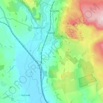
Name: Settle topographic map, elevation, terrain.
Average elevation: 238 m
Minimum elevation: 123 m
Maximum elevation: 515 m
Make a donation
Other topographic maps
Click on a map to view its topography, its elevation and its terrain.
Farndale
United Kingdom > England > North Yorkshire > Ryedale > Gillamoor
With the population having decreased greatly from the 668 that is recorded in "A Topographical Dictionary of Yorkshire" by Thomas Lansdale published in 1822 when farndale East side had a population of 455 and Farndale West Side had a Population of 213.
Average elevation: 273 m
Make a donation
Make a donation
Make a donation
Make a donation
Make a donation
Make a donation
Make a donation
Make a donation
Make a donation
Make a donation
Make a donation
Make a donation
Make a donation
Bolton Castle
United Kingdom > England > North Yorkshire > Redmire > Castle Bolton
Average elevation: 250 m
Thimbleby & Osmotherly Show field
United Kingdom > England > North Yorkshire > Thimbleby
Average elevation: 152 m
Make a donation
Make a donation
Make a donation
Make a donation
Make a donation
Killinghall
United Kingdom > England > North Yorkshire > Harrogate > Killinghall
Average elevation: 86 m
Make a donation
Make a donation
Make a donation
Make a donation
Make a donation
Arkle Town
United Kingdom > England > North Yorkshire > Richmondshire > Arkle Town
Average elevation: 367 m
Swinithwaite
United Kingdom > England > North Yorkshire > Richmondshire > West Witton > Swinithwaite
Average elevation: 205 m
Make a donation
Make a donation