
Ochsengarten topographic map
Interactive map
Click on the map to display elevation.
About this map
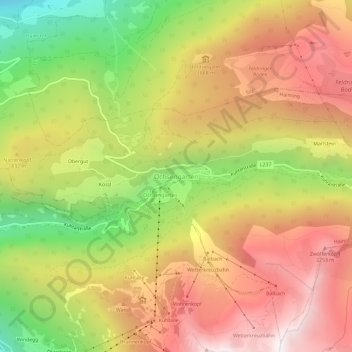
Name: Ochsengarten topographic map, elevation, terrain.
Average elevation: 1,768 m
Minimum elevation: 986 m
Maximum elevation: 2,429 m
Other topographic maps
Click on a map to view its topography, its elevation and its terrain.
Ötztal-Bahnhof
Oostenrijk > Tirol > Bezirk Imst > Gemeinde Haiming
Ötztal-Bahnhof, Gemeinde Haiming, Bezirk Imst, Tirol, 6430, Oostenrijk
Average elevation: 864 m