
Thank you for supporting this site ❤️
Make a donation
Make a donation
Parrish Gap topographic map
Click on the map to display elevation.
Thank you for supporting this site ❤️
Make a donation
Make a donation
About this map
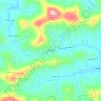
Name: Parrish Gap topographic map, elevation, terrain.
Location: Parrish Gap, Macon County, North Carolina, United States (35.20537 -83.47321 35.24537 -83.43321)
Average elevation: 694 m
Minimum elevation: 608 m
Maximum elevation: 919 m
Thank you for supporting this site ❤️
Make a donation
Make a donation
Other topographic maps
Click on a map to view its topography, its elevation and its terrain.
Little Tennessee River
United States > North Carolina > Macon County > Franklin > East Franklin
Average elevation: 641 m