
Make a donation
Al Taif topographic map
Click on the map to display elevation.
Make a donation
About this map
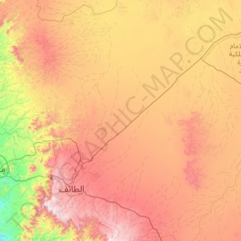
Name: Al Taif topographic map, elevation, terrain.
Location: Al Taif, Makkah Region, Saudi Arabia (20.87408 40.18608 22.68484 41.25623)
Average elevation: 1,104 m
Minimum elevation: 197 m
Maximum elevation: 2,534 m
Make a donation
Other topographic maps
Click on a map to view its topography, its elevation and its terrain.
Mecca
Saudi Arabia > Makkah Region > Makkah Al Mukarramah > Mecca
Mecca is at an elevation of 277 m (909 ft) above sea level, and approximately 80 km (50 mi) inland from the Red Sea. Central Mecca lies in a corridor between mountains, which is often called the "Hollow of Mecca". The area contains the valley of Al Taneem, the Valley of Bakkah and the valley of Abqar. This…
Average elevation: 313 m
Make a donation
At Ta'if
Taif (Arabic: اَلطَّائِفُ, romanized: aṭ-Ṭāʾif, lit. 'The circulated or encircled', Hejazi pronunciation: [atˤˈ tˤaːjɪf]) is a city and governorate in the Makkan Region of Saudi Arabia. Located at an elevation of 1,879 m (6,165 ft) in the slopes of the Hijaz Mountains, which…
Average elevation: 1,742 m
Make a donation
Jabal ar Rahmah
Saudi Arabia > Makkah Region > Makkah Al Mukarramah
Mount Arafat (Arabic: جَبَل عَرَفَات, romanized: Jabal ʿArafāt, or جَبَل ٱلرَّحْمَة, Jabal ar-Raḥmah, 'Mountain of Mercy') is a granodiorite hill about 20 km (12 mi) southeast of Mecca, in the province of the same name in Saudi Arabia. It is approximately 70 m (230 ft) in…
Average elevation: 331 m
At Ta'if
Taif (Arabic: اَلطَّائِفُ, romanized: Aṭ-Ṭāʾif, lit. 'The circulated or encircled', Hejazi Arabic pronunciation: [atˤˈ tˤaː(j)ɪf]) is a city and governorate in Mecca Province in Saudi Arabia. Located at an elevation of 1,879 m (6,165 ft) in the slopes of the Hijaz Mountains, which…
Average elevation: 1,742 m
Make a donation
At Ta'if
Taif (Arabic: اَلطَّائِفُ, romanized: aṭ-Ṭāʾif, lit. 'The circulated or encircled', Hejazi Arabic pronunciation: [atˤˈ tˤaː(j)ɪf]) is a city and governorate in the Mecca Province of Saudi Arabia. Located at an elevation of 1,879 m (6,165 ft) in the slopes of the Hijaz Mountains,…
Average elevation: 1,742 m
At Ta'if
Taif (Arabic: اَلطَّائِفُ, romanized: Aṭ-Ṭāʾif, lit. 'The circulated or encircled', Hejazi Arabic pronunciation: [atˤˈ tˤaː(j)ɪf]) is a city and governorate in the Province of Makkah in Saudi Arabia. Located at an elevation of 1,879 m (6,165 ft) in the slopes of the Hijaz Mountains,…
Average elevation: 1,742 m
Make a donation
Make a donation
At Ta'if
Taif (Arabic: اَلطَّائِفُ, romanized: Aṭ-Ṭāʾif, lit. 'The circulated or encircled', Hejazi Arabic pronunciation: [atˤˈ tˤaː(j)ɪf]) is a city and governorate in Mecca Province in Saudi Arabia. Located at an elevation of 1,879 m (6,165 ft) in the slopes of the Hijaz Mountains, which…
Average elevation: 1,742 m
Make a donation
Make a donation
Jabal ar Rahmah
Saudi Arabia > Makkah Region > Makkah Al Mukarramah
Mount Arafat (Arabic: جَبَل عَرَفَات, romanized: Jabal ʿArafāt, or جَبَل ٱلرَّحْمَة, Jabal ar-Raḥmah, 'Mountain of Mercy') is a granodiorite hill about 20 km (12 mi) southeast of Mecca, in the province of the same name in Saudi Arabia. It is approximately 70 m (230 ft) in…
Average elevation: 331 m
Make a donation
Make a donation
Make a donation
Make a donation
Make a donation
Make a donation
At Ta'if
Taif (Arabic: اَلطَّائِفُ, romanized: Aṭ-Ṭāʾif, lit. 'The circulated or encircled', Hejazi Arabic pronunciation: [atˤˈ tˤaː(j)ɪf]) is a city and governorate in Mecca Province in Saudi Arabia. Located at an elevation of 1,879 m (6,165 ft) in the slopes of the Hijaz Mountains, which…
Average elevation: 1,742 m
Make a donation
Make a donation
Make a donation
Make a donation
Make a donation