
Gemeinde Hittisau topographic map
Interactive map
Click on the map to display elevation.
About this map
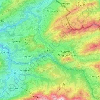
Name: Gemeinde Hittisau topographic map, elevation, terrain.
Location: Gemeinde Hittisau, Bezirk Bregenz, Vorarlberg, 6952, Österreich (47.42683 9.92821 47.48918 10.10389)
Average elevation: 1,057 m
Minimum elevation: 555 m
Maximum elevation: 1,855 m