
Make a donation
Big Horn County topographic map
Click on the map to display elevation.
Make a donation
About this map
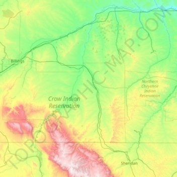
Name: Big Horn County topographic map, elevation, terrain.
Location: Big Horn County, Montana, United States (44.99372 -108.69985 46.04381 -106.26361)
Average elevation: 1,219 m
Minimum elevation: 745 m
Maximum elevation: 3,086 m
Make a donation
Other topographic maps
Click on a map to view its topography, its elevation and its terrain.
Make a donation
Make a donation
Make a donation
Kootenai River
United States > Montana > Lincoln County
Comparisons of various U.S. Geological Survey (USGS) topographic maps from the 20th century show many misinterpretations or alternative names being applied to the segment of the river within the United States. These include "Kootanie", "Kootenie", and "Kootienay". The Geographic Names Information System of the…
Average elevation: 864 m
Make a donation
Yellowstone River
United States > Montana > Custer County
The mainstem of the Yellowstone River is more than 700 miles (1,100 km) long. At the headwaters, elevations exceed 12,800 feet (3,900 m) above sea level, descending to 1,850 feet (560 m) at the confluence with the Missouri River in far western North Dakota. The watershed spans 34,167 square miles (88,490 km2).…
Average elevation: 719 m
Bitterroot Range
United States > Montana > Ravalli County
The site of Brower's Spring is at about 8,800 feet (2,680 m) in elevation in the Centennials. The site is now commemorated by a rock cairn at the source of Hellroaring Creek, which flows into the Red Rock River and then into Clark canyon reservoir, where it joins the Beaverhead River and then the Big Hole…
Average elevation: 2,112 m
Make a donation
Make a donation
Make a donation
Make a donation
Make a donation
Make a donation
Make a donation
Make a donation
Fort Peck Indian Reservation Historical Marker
United States > Montana > Roosevelt County > Poplar
Average elevation: 600 m
Make a donation
Make a donation
Crazy Mountains Historical Marker
United States > Montana > Wheatland County
Average elevation: 1,315 m
Make a donation
Make a donation
Make a donation
Gallatin Gateway
United States > Montana > Gallatin County
Gallatin Gateway is a census-designated place (CDP) in Gallatin County, Montana, United States. As of the 2020 census, Gallatin Gateway had a population of 967. Elevation is 4,953 ft (1,510 m).
Average elevation: 1,519 m
Make a donation
Make a donation
Make a donation
Make a donation
Homestake Pass
United States > Montana > Silver Bow County > Butte > Highview
Average elevation: 1,947 m
Make a donation
Make a donation
Make a donation
Make a donation