
Tongeren topographic map
Interactive map
Click on the map to display elevation.
About this map
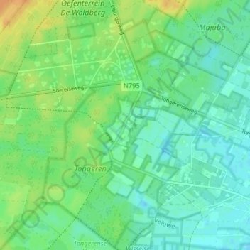
Name: Tongeren topographic map, elevation, terrain.
Location: Tongeren, Epe, Gelderland, Nederland, 8162 PD, Nederland (52.33361 5.90168 52.37361 5.94168)
Average elevation: 26 m
Minimum elevation: 15 m
Maximum elevation: 46 m
Other topographic maps
Click on a map to view its topography, its elevation and its terrain.
Kasteel Cannenburch
Nederland > Gelderland > Epe
Kasteel Cannenburch, Maarten van Rossumplein, Vaassen, Epe, Gelderland, Nederland, 8171CS, Nederland
Average elevation: 15 m