
Thank you for supporting this site ❤️
Make a donation
Make a donation
Schafsiedel topographic map
Click on the map to display elevation.
Thank you for supporting this site ❤️
Make a donation
Make a donation
About this map
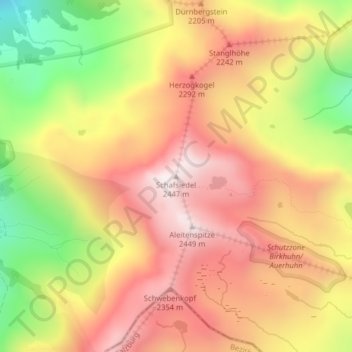
Name: Schafsiedel topographic map, elevation, terrain.
Average elevation: 2,086 m
Minimum elevation: 1,624 m
Maximum elevation: 2,431 m
Thank you for supporting this site ❤️
Make a donation
Make a donation
Other topographic maps
Click on a map to view its topography, its elevation and its terrain.
Kelchsau
Österreich > Tirol > Bezirk Kitzbühel > Hopfgarten im Brixental > Kelchsau
Average elevation: 1,134 m