
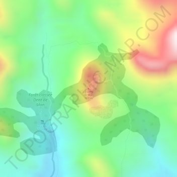
La Dent de Man topographic map
Interactive map
Click on the map to display elevation.
About this map
Name: La Dent de Man topographic map, elevation, terrain.
Location: La Dent de Man, Man, Tonkpi, Montagnes, 1316, Côte d’Ivoire (7.45630 -7.54438 7.45640 -7.54428)
Average elevation: 568 m
Minimum elevation: 352 m
Maximum elevation: 916 m
Other topographic maps
Click on a map to view its topography, its elevation and its terrain.
Man
Côte d’Ivoire > Montagnes > Man
Man, Tonkpi, Montagnes, 420, Côte d’Ivoire
Average elevation: 451 m
Mont Gouané
Côte d’Ivoire > Montagnes > Man
Mont Gouané, Man, Tonpki, Montagnes, Côte d’Ivoire
Average elevation: 842 m
Mont Tonkpi
Côte d’Ivoire > Montagnes > Man
Mont Tonkpi, Man, Tonpki, Montagnes, Côte d’Ivoire
Average elevation: 902 m