
Clinton topographic map
Interactive map
Click on the map to display elevation.
About this map
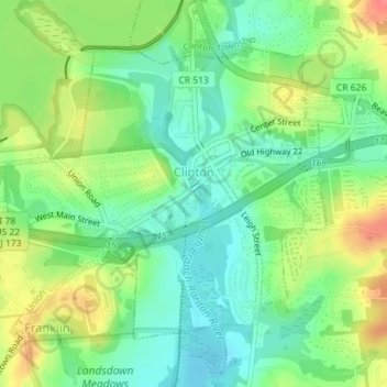
Name: Clinton topographic map, elevation, terrain.
Location: Clinton, Hunterdon County, New Jersey, 08809, United States (40.62457 -74.92905 40.64494 -74.89946)
Average elevation: 74 m
Minimum elevation: 48 m
Maximum elevation: 114 m
Clinton falls under the "Northern New Jersey" climate zone. According to the Office of the New Jersey State Climatologist at Rutgers University, the Northern climate zone covers about one-quarter of New Jersey and consists mainly of elevated highlands and valleys which are part of the Appalachian Uplands. Surrounded by land, this region can be characterized as having a continental climate with minimal influence from the Atlantic Ocean, except when the winds contain an easterly component. Prevailing winds are from the southwest in summer and from the northwest in winter. Being in the northernmost portion of the state, and with small mountains up to 1,800 feet (550 m) in elevation, the Northern Zone normally exhibits a colder temperature regime than other climate regions of the State of New Jersey. This difference is most dramatic in winter when average temperatures in the Northern Zone can be more than ten degrees Fahrenheit cooler than in the Coastal Zone. Annual snowfall averages 40 to 50 inches (100 to 130 cm) in the northern zone as compared with an average of 10 to 15 inches (25 to 38 cm) in the extreme south.