
Solingen topographic map
Interactive map
Click on the map to display elevation.
About this map
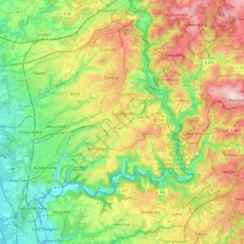
Name: Solingen topographic map, elevation, terrain.
Location: Solingen, North Rhine – Westphalia, Germany (51.11420 6.95110 51.22038 7.17408)
Average elevation: 184 m
Minimum elevation: 55 m
Maximum elevation: 371 m
Other topographic maps
Click on a map to view its topography, its elevation and its terrain.
Kempen
Germany > North Rhine – Westphalia > Kreis Viersen
Kempen, Kreis Viersen, North Rhine – Westphalia, 47906, Germany
Average elevation: 35 m
Schulenberg
Germany > North Rhine – Westphalia > Ennepe-Ruhr-Kreis > Hattingen
Schulenberg, Hattingen, Ennepe-Ruhr-Kreis, North Rhine – Westphalia, 45525, Germany
Average elevation: 130 m
Cologne
Germany > North Rhine – Westphalia
Cologne, North Rhine – Westphalia, Germany
Average elevation: 69 m
Wuppertal
Germany > North Rhine – Westphalia
Wuppertal, North Rhine – Westphalia, Germany
Average elevation: 242 m
Bochum
Germany > North Rhine – Westphalia
Bochum, North Rhine – Westphalia, Germany
Average elevation: 99 m