
Hefei City topographic map
Interactive map
Click on the map to display elevation.
About this map
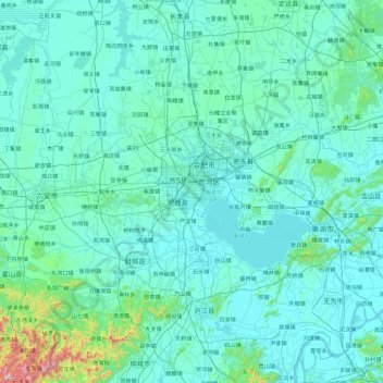
Name: Hefei City topographic map, elevation, terrain.
Location: Hefei City, Anhui, China (30.96130 116.68669 32.54107 117.96794)
Average elevation: 66 m
Minimum elevation: 0 m
Maximum elevation: 1,434 m
Other topographic maps
Click on a map to view its topography, its elevation and its terrain.
Fenghuangshan
China > Anhui > Chaohu City
Fenghuangshan, Chaohu City, Hefei, Anhui, 238000, China
Average elevation: 50 m
Gongyang Mountain
China > Anhui > 黄山风景区 > Alchemy Peak
Gongyang Mountain, Alchemy Peak, 黄山风景区, Huangshan District, Huangshan City, Anhui, China
Average elevation: 1,501 m