
Thank you for supporting this site ❤️
Make a donation
Make a donation
Richland County topographic map
Click on the map to display elevation.
Thank you for supporting this site ❤️
Make a donation
Make a donation
About this map
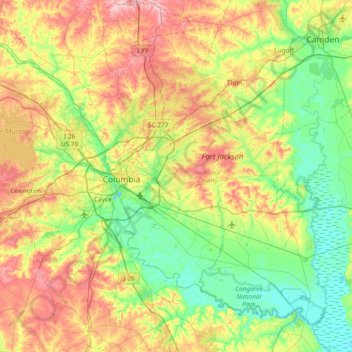
Name: Richland County topographic map, elevation, terrain.
Location: Richland County, South Carolina, United States (33.74324 -81.34531 34.26876 -80.59621)
Average elevation: 84 m
Minimum elevation: 23 m
Maximum elevation: 194 m
Thank you for supporting this site ❤️
Make a donation
Make a donation
Other topographic maps
Click on a map to view its topography, its elevation and its terrain.
Harbour Town
United States > South Carolina > Beaufort County > Hilton Head Island
Average elevation: 2 m
Park Place
United States > South Carolina > Anderson County > Anderson > Park Place
Average elevation: 234 m
Thank you for supporting this site ❤️
Make a donation
Make a donation