
Wald im Pinzgau topographic map
Interactive map
Click on the map to display elevation.
About this map
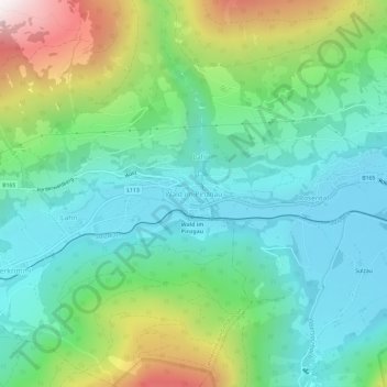
Name: Wald im Pinzgau topographic map, elevation, terrain.
Average elevation: 1,163 m
Minimum elevation: 840 m
Maximum elevation: 1,976 m
Other topographic maps
Click on a map to view its topography, its elevation and its terrain.
Königsleiten
Österreich > Salzburg > Bezirk Zell am See > Gemeinde Wald im Pinzgau
Königsleiten, Gemeinde Wald im Pinzgau, Bezirk Zell am See, Salzburg, 5742, Österreich
Average elevation: 1,703 m