
Modi topographic map
Interactive map
Click on the map to display elevation.
About this map
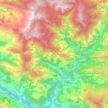
Name: Modi topographic map, elevation, terrain.
Location: Modi, Parbat, Gandaki, 33200, Nepal (28.22213 83.65730 28.39939 83.82239)
Average elevation: 1,857 m
Minimum elevation: 687 m
Maximum elevation: 3,305 m
Other topographic maps
Click on a map to view its topography, its elevation and its terrain.