
Thank you for supporting this site ❤️
Make a donation
Make a donation
Ashbourne topographic map
Click on the map to display elevation.
Thank you for supporting this site ❤️
Make a donation
Make a donation
About this map
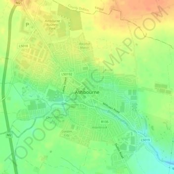
Name: Ashbourne topographic map, elevation, terrain.
Location: Ashbourne, County Meath, Leinster, Ireland (53.49839 -6.41472 53.52639 -6.38156)
Average elevation: 73 m
Minimum elevation: 52 m
Maximum elevation: 91 m
Thank you for supporting this site ❤️
Make a donation
Make a donation
Other topographic maps
Click on a map to view its topography, its elevation and its terrain.