
Habay topographic map
Interactive map
Click on the map to display elevation.
About this map
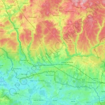
Name: Habay topographic map, elevation, terrain.
Location: Habay, Virton, Luxembourg, Wallonia, Belgium (49.68725 5.50065 49.78399 5.71318)
Average elevation: 396 m
Minimum elevation: 322 m
Maximum elevation: 505 m
Other topographic maps
Click on a map to view its topography, its elevation and its terrain.
Ethe
Belgium > Luxembourg > Virton > Virton
Ethe, Virton, Luxembourg, Wallonia, Belgium
Average elevation: 293 m
Saint-Mard
Belgium > Luxembourg > Virton > Virton
Saint-Mard, Virton, Luxembourg, Wallonia, 6762, Belgium
Average elevation: 272 m
Florenville
Belgium > Luxembourg > Virton
Florenville, Virton, Luxembourg, Wallonia, Belgium
Average elevation: 316 m