
Make a donation
Benzingerode topographic map
Click on the map to display elevation.
Make a donation
About this map
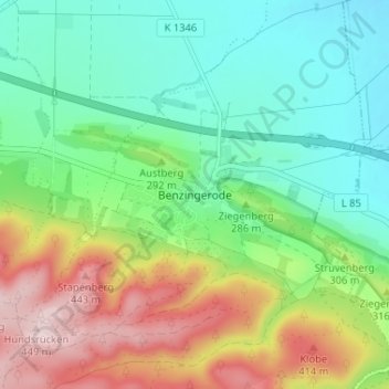
Name: Benzingerode topographic map, elevation, terrain.
Average elevation: 275 m
Minimum elevation: 174 m
Maximum elevation: 464 m
Make a donation
Other topographic maps
Click on a map to view its topography, its elevation and its terrain.
Schierke
Deutschland > Sachsen-Anhalt > Landkreis Harz > Wernigerode
2011 wurde durch die Stadt Wernigerode ein umfangreiches Investitionsprogramm für Schierke aufgelegt. Bis 2015 flossen rund 40 Millionen Euro in die Ortsentwicklung, vor allem in Straßen, Brücken, Parkplätze, Hotels und Sportangebote. Das Konzept des Berliner Architekten Wolf-Rüdiger Eisentraut sieht vor,…
Average elevation: 707 m
Make a donation
Eckertalsperre
Deutschland > Sachsen-Anhalt > Landkreis Harz > Wernigerode > Schierke
Average elevation: 609 m
Schierke
Deutschland > Sachsen-Anhalt > Landkreis Harz > Wernigerode
2011 wurde durch die Stadt Wernigerode ein umfangreiches Investitionsprogramm für Schierke aufgelegt. Bis 2015 flossen rund 40 Millionen Euro in die Ortsentwicklung, vor allem in Straßen, Brücken, Parkplätze, Hotels und Sportangebote. Das Konzept des Berliner Architekten Wolf-Rüdiger Eisentraut sieht vor,…
Average elevation: 706 m