
Sidi Maarouf topographic map
Interactive map
Click on the map to display elevation.
About this map
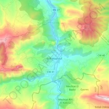
Name: Sidi Maarouf topographic map, elevation, terrain.
Location: Sidi Maarouf, Daïra Sidi Maarouf, Jijel, 18018, Algérie (36.60868 6.20359 36.67952 6.35147)
Average elevation: 524 m
Minimum elevation: 35 m
Maximum elevation: 1,439 m
Other topographic maps
Click on a map to view its topography, its elevation and its terrain.
Ouled Rabah
Algérie > Jijel > Daïra Sidi Maarouf
Ouled Rabah, Daïra Sidi Maarouf, Jijel, Algérie
Average elevation: 830 m