
Thank you for supporting this site ❤️
Make a donation
Make a donation
Edingen topographic map
Click on the map to display elevation.
Thank you for supporting this site ❤️
Make a donation
Make a donation
About this map
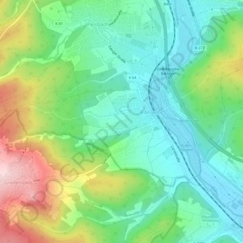
Name: Edingen topographic map, elevation, terrain.
Location: Edingen, Sinn, Lahn-Dill-Kreis, Hessen, Deutschland (50.62213 8.29077 50.64102 8.34646)
Average elevation: 271 m
Minimum elevation: 180 m
Maximum elevation: 457 m
Thank you for supporting this site ❤️
Make a donation
Make a donation
Other topographic maps
Click on a map to view its topography, its elevation and its terrain.