
Drübeck topographic map
Interactive map
Click on the map to display elevation.
About this map
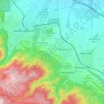
Name: Drübeck topographic map, elevation, terrain.
Average elevation: 321 m
Minimum elevation: 201 m
Maximum elevation: 608 m
Drübeck liegt auf einer Höhe von 258 m ü. NN am Nordrand des Harzes zwischen Darlingerode im Osten und Ilsenburg (Harz) im Westen. Südlich des Dorfes liegt Oehrenfeld.
Other topographic maps
Click on a map to view its topography, its elevation and its terrain.
Darlingerode
Deutschland > Sachsen-Anhalt > Landkreis Harz > Ilsenburg
Darlingerode, Ilsenburg, Landkreis Harz, Sachsen-Anhalt, 38831, Deutschland
Average elevation: 256 m
Pulvermühle
Deutschland > Sachsen-Anhalt > Landkreis Harz > Ilsenburg
Pulvermühle, Ilsenburg, Landkreis Harz, Sachsen-Anhalt, 38871, Deutschland
Average elevation: 224 m
Untere Zeterklippen
Deutschland > Sachsen-Anhalt > Landkreis Harz > Ilsenburg
Untere Zeterklippen, Ilsenburg, Landkreis Harz, Sachsen-Anhalt, 38879, Deutschland
Average elevation: 763 m
Ernstburg
Deutschland > Sachsen-Anhalt > Landkreis Harz > Ilsenburg
Ernstburg, Ilsenburg, Landkreis Harz, Sachsen-Anhalt, 38871, Deutschland
Average elevation: 532 m