
อำเภอเมืองภูเก็ต topographic map
Interactive map
Click on the map to display elevation.
About this map
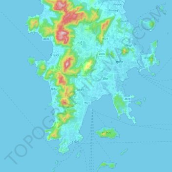
Name: อำเภอเมืองภูเก็ต topographic map, elevation, terrain.
Location: อำเภอเมืองภูเก็ต, Phuket, Thaïlande (7.73315 98.27221 7.96954 98.48294)
Average elevation: 33 m
Minimum elevation: 0 m
Maximum elevation: 518 m
Other topographic maps
Click on a map to view its topography, its elevation and its terrain.
กะรน
Thaïlande > Phuket > อำเภอเมืองภูเก็ต > ตำบลกะรน
กะรน, ตำบลกะรน, อำเภอเมืองภูเก็ต, Phuket, 83100, Thaïlande
Average elevation: 75 m