
Pöschlturm topographic map
Interactive map
Click on the map to display elevation.
About this map
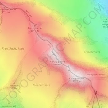
Name: Pöschlturm topographic map, elevation, terrain.
Average elevation: 3,185 m
Minimum elevation: 2,428 m
Maximum elevation: 3,687 m
Other topographic maps
Click on a map to view its topography, its elevation and its terrain.
Großglockner
Oostenrijk > Karinthië > Bezirk Spittal an der Drau > Heiligenblut am Großglockner
Großglockner, Heiligenblut am Großglockner, Bezirk Spittal an der Drau, Karinthië, Oostenrijk
Average elevation: 3,128 m