
La Bruyère topographic map
Interactive map
Click on the map to display elevation.
About this map
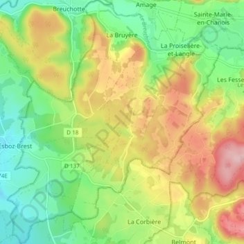
Name: La Bruyère topographic map, elevation, terrain.
Average elevation: 382 m
Minimum elevation: 308 m
Maximum elevation: 482 m
Son territoire communal s'étend sur 6,32 [km et varie d'une altitude de 309 m à 426 m.
Other topographic maps
Click on a map to view its topography, its elevation and its terrain.
Plancher-Bas
France > Bourgogne-Franche-Comté > Haute-Saône
Plancher-Bas, Lure, Haute-Saône, Bourgogne-Franche-Comté, France métropolitaine, 70290, France
Average elevation: 525 m
Villers-la-Ville
France > Bourgogne-Franche-Comté > Haute-Saône
Villers-la-Ville, Lure, Haute-Saône, Bourgogne-Franche-Comté, France métropolitaine, 70110, France
Average elevation: 286 m
Fougerolles
France > Bourgogne-Franche-Comté > Haute-Saône > Fougerolles-Saint-Valbert
Fougerolles, Fougerolles-Saint-Valbert, Lure, Haute-Saône, Bourgogne-Franche-Comté, France métropolitaine, 70220, France
Average elevation: 399 m
Mélisey
France > Bourgogne-Franche-Comté > Haute-Saône
Mélisey, Lure, Haute-Saône, Bourgogne-Franche-Comté, France métropolitaine, 70270, France
Average elevation: 401 m