
Fort Hunter topographic map
Interactive map
Click on the map to display elevation.
About this map
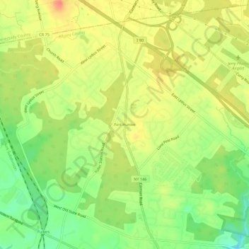
Name: Fort Hunter topographic map, elevation, terrain.
Average elevation: 99 m
Minimum elevation: 69 m
Maximum elevation: 124 m
Other topographic maps
Click on a map to view its topography, its elevation and its terrain.
Westmere
United States > New York > Albany County > Town of Guilderland
Westmere, Town of Guilderland, Albany County, New York, United States
Average elevation: 79 m
Village of Altamont
United States > New York > Albany County > Town of Guilderland
Village of Altamont, Town of Guilderland, Albany County, New York, United States
Average elevation: 158 m
North Bethlehem
United States > New York > Albany County > Town of Guilderland
North Bethlehem, Town of Guilderland, Albany County, New York, 12203, United States
Average elevation: 65 m
Meadowdale
United States > New York > Albany County > Town of Guilderland
Meadowdale, Town of Guilderland, Albany County, New York, 12085, United States
Average elevation: 115 m
Dunnsville
United States > New York > Albany County > Town of Guilderland
Dunnsville, Town of Guilderland, Albany County, New York, 12009, United States
Average elevation: 130 m
Fullers
United States > New York > Albany County > Town of Guilderland
Fullers, Town of Guilderland, Albany County, New York, 12085, United States
Average elevation: 90 m
Hartmans Corners
United States > New York > Albany County > Town of Guilderland
Hartmans Corners, Town of Guilderland, Albany County, New York, 12084, United States
Average elevation: 81 m
Guilderland Center
United States > New York > Albany County > Town of Guilderland
Guilderland Center, Town of Guilderland, Albany County, New York, 12085, United States
Average elevation: 96 m