
Pesterwitz topographic map
Interactive map
Click on the map to display elevation.
About this map
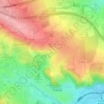
Name: Pesterwitz topographic map, elevation, terrain.
Average elevation: 234 m
Minimum elevation: 156 m
Maximum elevation: 306 m
Other topographic maps
Click on a map to view its topography, its elevation and its terrain.
Kuhberg
Deutschland > Sachsen > Freital
Kuhberg, Freital, Sächsische Schweiz-Osterzgebirge, Sachsen, 01734, Deutschland
Average elevation: 273 m
Raschelberg
Deutschland > Sachsen > Freital
Raschelberg, Freital, Sächsische Schweiz-Osterzgebirge, Sachsen, 01705, Deutschland
Average elevation: 260 m