
Mitte topographic map
Interactive map
Click on the map to display elevation.
About this map
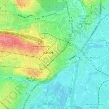
Name: Mitte topographic map, elevation, terrain.
Location: Mitte, Kassel, Regierungsbezirk Kassel, Hessen, 34117, Alemanha (51.30841 9.47021 51.32165 9.50672)
Average elevation: 160 m
Minimum elevation: 134 m
Maximum elevation: 211 m
Other topographic maps
Click on a map to view its topography, its elevation and its terrain.