
Coaldale topographic map
Interactive map
Click on the map to display elevation.
About this map
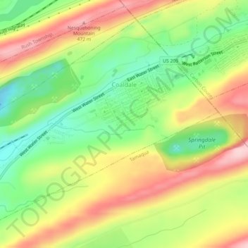
Name: Coaldale topographic map, elevation, terrain.
Location: Coaldale, Schuylkill County, Pennsylvania, United States (40.80536 -75.93620 40.83374 -75.89154)
Average elevation: 360 m
Minimum elevation: 252 m
Maximum elevation: 479 m
Coaldale is located at 40°49′20″N 75°54′36″W / 40.82222°N 75.91000°W / 40.82222; -75.91000 (40.822234, -75.910115), which is (technically) one mile southwest of Lansford as both municipalities lie along the border of Carbon and Schuylkill Counties. It is also five miles northeast of Tamaqua, 27 miles northwest of Allentown, and nine miles south of Hazleton. It is located on the northwestern fringe of the Lehigh Valley and just two ridgelines away from the nearby Poconos, and drains to the Delaware River by way of Panther Creek, the Little Schuylkill River, and the Schuylkill River. Coaldale sits atop one of the richest coal seams in the eastern end of the southern Coal Region, which is still being exploited by a successor company of the LC&N (called the Old Company in the valley), the Lehigh Coal and Navigation Company (or the New Company). Coaldale's elevation is 1050 feet above sea level. According to the United States Census Bureau, the borough has a total area of 2.2 square miles (5.7 km2), all land.
Other topographic maps
Click on a map to view its topography, its elevation and its terrain.
New Mines
United States > Pennsylvania > Schuylkill County > Reilly Township
New Mines, Reilly Township, Schuylkill County, Pennsylvania, 17923, United States
Average elevation: 338 m
Butler Township
United States > Pennsylvania > Schuylkill County
Butler Township, Schuylkill County, Pennsylvania, United States
Average elevation: 392 m
Tamaqua
United States > Pennsylvania > Schuylkill County > Tamaqua
Tamaqua, Schuylkill County, Pennsylvania, 18252, United States
Average elevation: 352 m
Newtown
United States > Pennsylvania > Schuylkill County > Reilly Township > Newtown
Newtown, Reilly Township, Schuylkill County, Pennsylvania, United States
Average elevation: 301 m
Deer Lake
United States > Pennsylvania > Schuylkill County
Deer Lake, Schuylkill County, Pennsylvania, United States
Average elevation: 196 m