
Thank you for supporting this site ❤️
Make a donation
Make a donation
Tikona Peth topographic map
Click on the map to display elevation.
Thank you for supporting this site ❤️
Make a donation
Make a donation
About this map
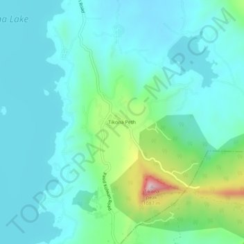
Name: Tikona Peth topographic map, elevation, terrain.
Location: Tikona Peth, Mawal, Pune, Maharashtra, 410406, India (18.62249 73.48737 18.66249 73.52737)
Average elevation: 676 m
Minimum elevation: 590 m
Maximum elevation: 1,033 m
Thank you for supporting this site ❤️
Make a donation
Make a donation
Other topographic maps
Click on a map to view its topography, its elevation and its terrain.