
Legazpi topographic map
Click on the map to display elevation.
Legazpi
Legazpi's topography is generally plain on the northeastern areas, with slopes ranging from five to fifteen degrees. The southern areas have mostly rolling to hilly terrain. In the city's coastal areas, the terrain varies from plain (north) to hilly (south). Legazpi is criss-crossed by several rivers including the Tibu, Macabalo and Yawa rivers with a number of swampy areas, particularly in the urban district. To mitigate flooding in these low-lying areas, the local government has built an urban drainage and flood control system consisting of dikes, canals, sea walls and three pumping stations located in Barangays San Roque, Bay-Bay and Victory Village.
About this map
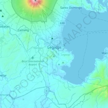
Name: Legazpi topographic map, elevation, terrain.
Location: Legazpi, Albay, Bicol Region, 4500, Philippines (12.98740 123.68618 13.25551 123.86397)
Average elevation: 124 m
Minimum elevation: -2 m
Maximum elevation: 2,431 m
Other topographic maps
Click on a map to view its topography, its elevation and its terrain.